|
|
|
TOPOWIN 14.01 |
 |
| License : |
Shareware |
| Release : |
All databases actualized on 1st January 2015. 8100 new town quarters added. 34600 location coordinates changed with higher accuracy. Output of window contents in GIF and BMP files. Uses ANSI character set instead of ASCII. WIN8, WIN7 and WIN-Vista certification renewed. |
| Price : |
$150.00 US |
| Language : |
English,German |
| File Size : |
3.585 MB |
|
|
|
|
|
Click to enlarge image
|
Description :
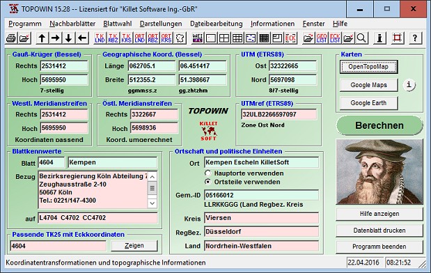
TOPOWIN is a state-wide register of the German Topographic Cartographies, the German Basic Cartography and of localities with geo references in different coordinate systems. It is also a topographic information system. In the division of planning and execution of economical and scientific projects frequently topographic documents are used. The program TOPOWIN makes information available of the official topographic cartographies and the German Basic Cartography from the entire national territory in suitable graphic views. It accomplishes different coordinate transformations and inquiries. The program was developed under co-operation of the land surveying authorities of many German Federal States. For the first time in the previous version TOPO (for DOS) and later in TOPOWIN state-wide topographic information were arranged for the data technical evaluation. The program is for consulting engineers, planning authorities and users of topographic maps a useful and versatile tool. The topographical maps of different standards, required for a project, can be determined by the entering of known parameters or by the direct selection from overview graphics and from sorted lists. By the investigation of topographical records on the basis of known places, a data base with more then 105.000 places and residential districts is available. The program TOPOWIN calculates with Gauss Krueger coordinates and Geographic Coordinates refering to the Potsdam Datum (Bessel ellipsoid with central point Rauenberg). It also works with UTM coordinates and UTMRef coordinates in the NATO standard, which refer to the datum ETRS89 (GRS80 / WGS84, geocentric).
More information from program website
| Operating System : |
WinXP,WinVista,WinVista x64,Win7 x32,Win7 x64,Win2000,WinOther,Windows2000,Windows2003,WinServer,Windows Vista Ultimate,Windows Vista Ultimate x64,WinMobile,Windows CE,WinME,WinNT 3.x,WinNT 4.x,Window |
| System Requirements : |
Pentium, 50 MB HD |
| Order URL : |
|
| Download URL 1 : |
http://www.killetsoft.de/zip/topowin.zip |
| Report this |
I would like to report TOPOWIN 14.01 for :-
|
|
|
| Checkout these similar programs : |
|---|
| MidiRunner 1.39.0.3 | | | Play Center for MIDI,MP3,Wav,CD-Audio files, with Keyboard. MIDI Tracks, Lyrics | Shareware
| |
| | | | VistaMetrix 1.38 | | | Extracts graph values, distances, areas, angles, color values from graphics. | Shareware
| |
| | | | | | | G-Lock SpamCombat 3.0 | | | Your powerful solution for clearing Inbox from spam, virus, and junk emails | Freeware
| |
|
|
|